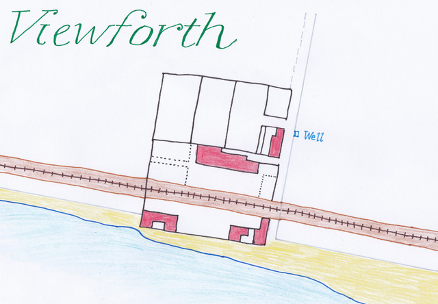
The above representation of Viewforth, which lies to the east of the Temple at Largo, is based upon the 1854 OS map. The buildings have evolved over the years - with bits added or taken away - but this is how it was captured in the earliest detailed map widely available. The 1825 advert for the sale of these grounds described the two-storey dwelling house named 'Viewforth' (the largest building in red at the centre) with its dining-room, parlour, kitchen and three bedrooms, plus adjoining stable. The advert also mentioned four small one storey houses, which can all be seen in the illustration. I imagine the whole settlement would have been quite self-sufficient, with vegetables grown, livestock kept and fish caught. There was a well to the east side.
The period when Viewforth (or Largo Pans) was a salt works is well-documented in the book 'Largo - An Illustrated History' by Eunson and Band. It places the origins of the works at 1759. The household account book of Lady Janet Anstruther lists 'salt from Largo' among the items purchased for the household between 1763 and 1770 (alongside such other items as a barrel of herrings, pint of gin, oysters from St Monans and hard biscuit from Leven). Other references to early Viewforth are hard to find but it seems that later in the 18th century salt production ceased and the site become more residential. The construction and arrival of the railway must have been hugely disruptive to inhabitants of Viewforth as the line cut the original site in two. Presumably compensation would have been paid for the loss of ground. Just to the east of Viewforth was the 'Strathairly siding' and the 'Viewforth level crossing'.
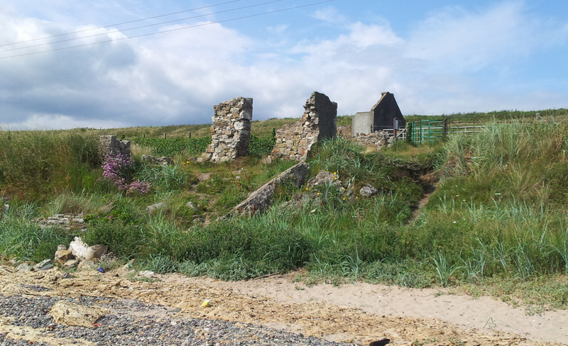
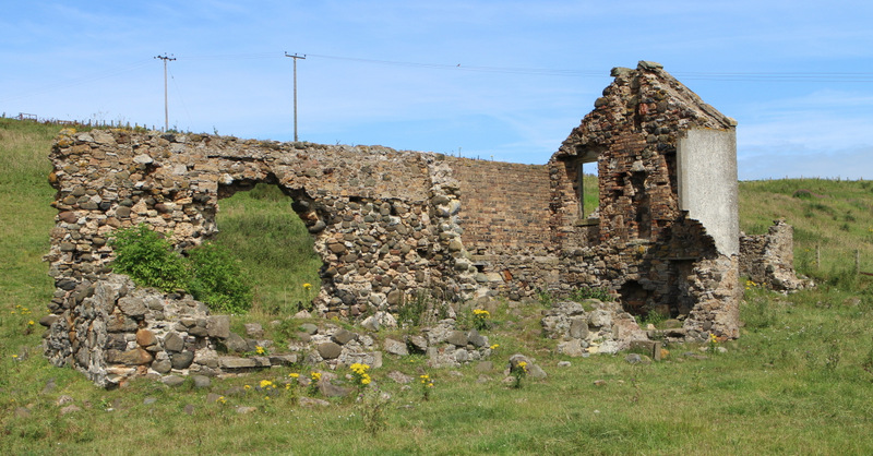
The photograph below was taken from the beach at the south west corner of the Viewforth site, looking up towards the main dwelling house. The ruined building in the foreground always was incredibly close to the high water mark, and must have witnessed some spectacular storms over the decades, but eventually coastal erosion rendered the houses closest to the sea uninhabitable. By the late 1940s they were abandoned. The image at the foot of this post shows the remains of the main dwelling house. It is easy to distinguish the original elements of the building from the later brick addition. Remnants of doors, windows, walls, and a chimney can also be seen.
The period when Viewforth (or Largo Pans) was a salt works is well-documented in the book 'Largo - An Illustrated History' by Eunson and Band. It places the origins of the works at 1759. The household account book of Lady Janet Anstruther lists 'salt from Largo' among the items purchased for the household between 1763 and 1770 (alongside such other items as a barrel of herrings, pint of gin, oysters from St Monans and hard biscuit from Leven). Other references to early Viewforth are hard to find but it seems that later in the 18th century salt production ceased and the site become more residential. The construction and arrival of the railway must have been hugely disruptive to inhabitants of Viewforth as the line cut the original site in two. Presumably compensation would have been paid for the loss of ground. Just to the east of Viewforth was the 'Strathairly siding' and the 'Viewforth level crossing'.
The photograph below was taken from the beach at the south west corner of the Viewforth site, looking up towards the main dwelling house. The ruined building in the foreground always was incredibly close to the high water mark, and must have witnessed some spectacular storms over the decades, but eventually coastal erosion rendered the houses closest to the sea uninhabitable. By the late 1940s they were abandoned. The image at the foot of this post shows the remains of the main dwelling house. It is easy to distinguish the original elements of the building from the later brick addition. Remnants of doors, windows, walls, and a chimney can also be seen.
 RSS Feed
