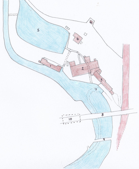
The above plan of the site of the mill, once situated by Lower Largo Harbour, is based upon the 1912 OS Map. The mill site existed long before then, of course, and it evolved a fair bit over time, with individual buildings being altered, adapted or replaced, as the nature of the businesses that occupied the site changed. However, the above illustration shows the three main buildings within the complex, as well as some additional structures. The numbered features are as follows:
1. One of the oldest buildings in the complex, which latterly housed a gas works and forge
2. Spinning Mill built 1798 and converted to Oil and Cake Mill circa 1861 (note 2 square extensions to rear built 1877)
3. One time 'Heckle House' (where flax was teased and combed out) with upstairs 'Counting House'
4. Manager's (or Overseer's) House
5. Mill Dam - with sluices marked left and right with dotted lines*
6. Building erected 1907 at the same time as a gas engine was installed at the mill
7. Course of the ford used by vehicles to cross Keil Burn prior to building of road bridge
8. Railway Viaduct (completed 1857)
9. Footbridge
10. Site of flax warehouse (pre-railway line) which would have had ford access from a ramp at edge of burn
* dotted lines show route of tunnels, the longest of which feeds the water wheel within building 2
The site was clearly well-placed, next to the point where the Keil Burn flows into Lower Largo Harbour, next to the road that connects the village to the main road at the top of Harbour Wynd and, eventually, next to Largo Railway Station. There was probably activity on this site long before existing records can prove. A brewery pre-dated the spinning mill, as did a lint mill. This blog has covered the early history of the 1798 mill before. In 1801, in addition to newly-built main building, there were also: a Malts Mill and Thirlage, a Waulk or Plash Mill (where cloth was cleaned and thickened), Ware-room, Heckle-house, Wright's Shop, Stable and Byre, as well as a Manager's House.
We have also looked before at how the mill evolved during the first half of the 19th century, before, ironically, falling out of use just as the railway line was about to reach Largo. Also covered previously, was the conversion of the mill into David Russell's Oil and Cake Mill. The reason for revisiting the subject is to better describe the geography of the site and to provide a frame of reference for a series of future posts on the transformation of the site after the old mill buildings were finally demolished in the late 1930s.
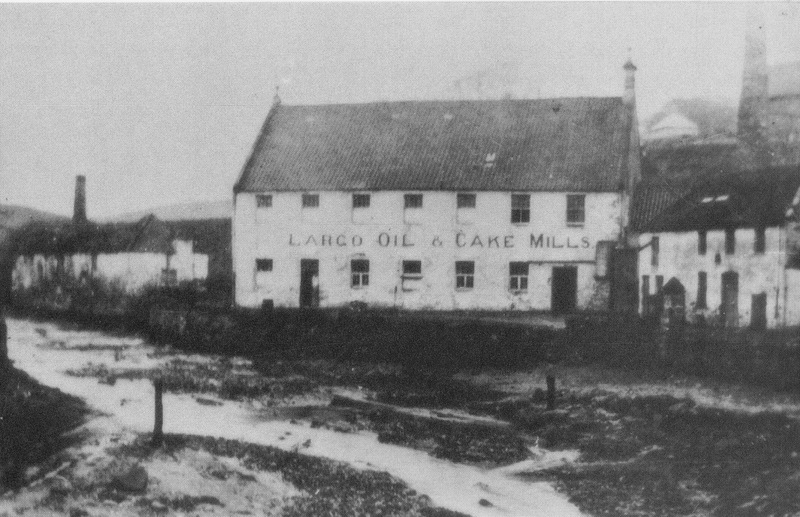
The image below shows the mill complex c1909 and shows, from left to right, buildings 1, 2 and 3 noted above. This image is featured on p84 of the book 'Largo - An Illustrated History' by Eunson and Band (2000).
With thanks to John Band for additional information regarding the mill site.
1. One of the oldest buildings in the complex, which latterly housed a gas works and forge
2. Spinning Mill built 1798 and converted to Oil and Cake Mill circa 1861 (note 2 square extensions to rear built 1877)
3. One time 'Heckle House' (where flax was teased and combed out) with upstairs 'Counting House'
4. Manager's (or Overseer's) House
5. Mill Dam - with sluices marked left and right with dotted lines*
6. Building erected 1907 at the same time as a gas engine was installed at the mill
7. Course of the ford used by vehicles to cross Keil Burn prior to building of road bridge
8. Railway Viaduct (completed 1857)
9. Footbridge
10. Site of flax warehouse (pre-railway line) which would have had ford access from a ramp at edge of burn
* dotted lines show route of tunnels, the longest of which feeds the water wheel within building 2
The site was clearly well-placed, next to the point where the Keil Burn flows into Lower Largo Harbour, next to the road that connects the village to the main road at the top of Harbour Wynd and, eventually, next to Largo Railway Station. There was probably activity on this site long before existing records can prove. A brewery pre-dated the spinning mill, as did a lint mill. This blog has covered the early history of the 1798 mill before. In 1801, in addition to newly-built main building, there were also: a Malts Mill and Thirlage, a Waulk or Plash Mill (where cloth was cleaned and thickened), Ware-room, Heckle-house, Wright's Shop, Stable and Byre, as well as a Manager's House.
We have also looked before at how the mill evolved during the first half of the 19th century, before, ironically, falling out of use just as the railway line was about to reach Largo. Also covered previously, was the conversion of the mill into David Russell's Oil and Cake Mill. The reason for revisiting the subject is to better describe the geography of the site and to provide a frame of reference for a series of future posts on the transformation of the site after the old mill buildings were finally demolished in the late 1930s.
The image below shows the mill complex c1909 and shows, from left to right, buildings 1, 2 and 3 noted above. This image is featured on p84 of the book 'Largo - An Illustrated History' by Eunson and Band (2000).
With thanks to John Band for additional information regarding the mill site.
 RSS Feed
