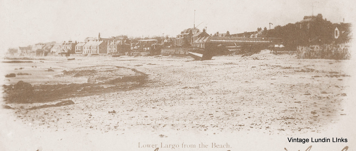
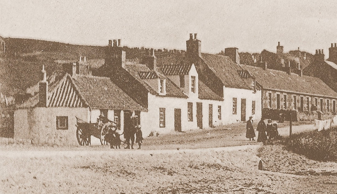
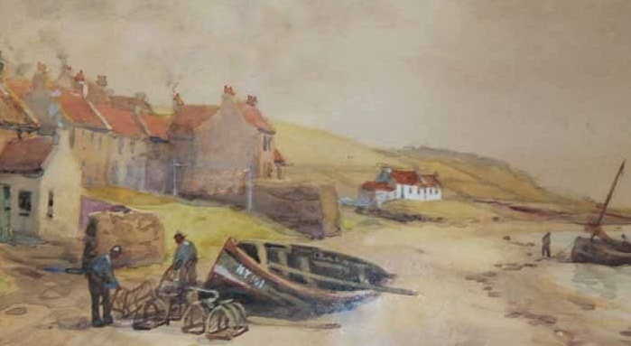
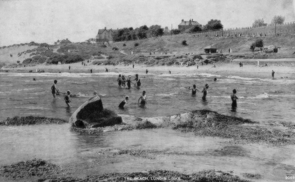
This atmospheric scene of Lower Largo featured on a postcard sent in July 1912. The sender was a John Rose who wrote "I am spending the day here with the choir picnic". This was sent to Miss Alexandrina Lowe of Kirkpark House, Musselburgh. Largo was a favourite day trip destination for many clubs and groups. The panorama stretches from the Crusoe Hotel on the left, round the bay to Cardy Works and Cardy House on the right. The start of The Temple is just visible on the extreme right - the prominent upper window of the central house in the group of white-coloured homes below stands out. This grouping of characterful buildings was once the entirety of the village of Temple (see painting at foot of post).
6 Comments
A previous post has shown an ice-cream van awaiting customers at Massney Braes by the beach at Lundin Links. The above image appears to show the same van but from a different angle on a different day. Probably dating to the early 1930s, there is plenty going on in the picture, so a couple of zoomed in images are shown below. The first image below shows the ice-cream van in more detail on the right. While on the left is a kind of stage - perhaps used by occasional performers (note also the lady reading a newspaper on the sand below this). Also clearly visible is the old road bridge over the railway line, which was removed in 1970. The second detailed image at the foot of this post, shows the former joiner's workshop in the upper right (originally the saltworks panhouse). Also visible are the old public toilets (long since demolished) - the white square building with castellated roof just left of centre in front of the trees. All in all there was more in the way of amenity and activity in this spot back then and during this era a bathing pool was very nearly built at the site too. This is the 'Glenfinnan' approaching Largo having passed Viewforth (see buildings to the right on the shore). The image, which appeared in the July 1964 'Railway World' magazine, was captured by WJV Anderson in August of 1957 - which was exactly 100 years after the opening of the line. To the left of the line is the poultry farm at Buckthorns Farm.
The magazine article noted that "like many other lines in Britain, the East Fife is under threat of closure. If the Beeching economic axe does chop it off, the memories will never be erased". Of course the axe did fall and the line closed in September 1965 to passenger traffic (with some goods services continuing for a brief spell thereafter). The Glenfinnan locomotive had met its demise in 1960 after almost fifty years of service. An image of it being cut up can be seen here: https://www.flickr.com/photos/93456400@N04/14742346492 If you have memories of the railway through Largo and Lundin Links, please comment! The circa 1950s view across Lundin Links beach towards Leven, Methil and Buckhaven shows the contrast between the people in the foreground enjoying themselves relaxing in the sun, buying ice-cream and paddling in the sea and the heavy industry taking place in the background. Below are some magnified views of the beach-goers at Massney Braes. The detail below shows the chimneys and industrial buildings to the west of Largo Bay - among them the Wellesley Colliery (see foot of post). The Wellesley operated from the mid-1880s until 1967. Methil Power Station became a prominent feature from the mid-1960s until 2011. Now wind turbines dot the horizon in this direction.
The above map is taken from the Pilot Handbook (East Coast of Scotland) of 1974. This book provides sailing directions, anchorages, harbours, etc to yacht users. Advice on the approach to Lower Largo then was as follows:
"Suitable for smaller yachts drawing up to 3ft. Approach from SE heading for the old railway viaduct (conspicuous). When about 100 yards offshore, line up on West face of pier and follow this line in - beware reef of rocks close on West side of this line (marked by poles) - stones on East side well covered near HW. Harbour open 2.5 hours either side of HW. Do not attempt entry in heavy onshore seas or if river in spate." The notes on mooring were: "Exposed anchorage about 1/4 mile offshore in about 1.5 fathoms on sandy bottom. Harbour space restricted. Yachts lie alongside Quay at Crusoe Hotel. Watch out for yachts lying off pier on running moorings. Bottom alongside pier fouled by some loose stones. Harbour liable to surge in onshore winds and can be dangerous if river in strong spate." The facilities in the "very attractive village...well worth a stay" were noted as "Water at hotel. Telephone at Bridge. Shops in village. Garage at main road (1/2 mile up hill). Several good hotels. Fish and Chip shop. HQ Largo Bay Sailing Club who have dinghy launching facilities. Good beach. Buses to Leven and East Neuk." Below is the map of the wider area included in the guide. Of Largo Bay, it was stated that "this bay shoals well out and is dangerous in strong onshore winds". Note the North Carr Lightship was still in service, anchored off Fife Ness, at the time. The following year - 1975 - it was taken out of service and served as a tourist attraction in Anstruther for many years thereafter. This vessel is currently awaiting restoration, with plans to exhibit her on Dundee waterfront. As a follow-up to the previous post on Johnston's Mill, here is an account of a ten-day camp which took place at the site in the summer of 1913. The 25 July Linlithgow Gazette reported that "The boys of the Armadale Company of the Boys' Brigade left for ten days camp at Johnston's Mill, Upper Largo, on Friday morning, in high spirits." After arriving at four o'clock and having tea, the boys had time to "find their bearings" before an eventful first night of "the usual fun of letting downs tents about their comrades". On Saturday morning the group "had their first view of a hydroplane coming along the water from Leven". A sail on Largo Bay and an evening concert on the beach followed. Sunday morning saw a parade to the United Free Church in Upper Largo, while Monday was filled with more sailing, bathing and watching the hydroplane. That evening the boys "were allowed to go out to Leven to witness the hydroplanes manoeuvring". Later in the week there were five-a-side football competitions and a march to Elie, from where they took a sail to North Berwick and round the Bass Rock. That the camp coincided with the visit of the Royal Flying Corps hydroplanes, which were undertaking exercises in the area throughout the summer months and had a temporary base at Leven, must have been thrilling. The images below show the hydroplane at Elie (upper image from 'The Harbours of Elie Bay - A History by Rennie) and at Leven (lower image from 'Bygone Leven' by Eunson). A 200-feet long tent was required on the links at Leven to house the machines and thirty six seamen as well as several petty officers and mechanics were stationed there. Despite attempts to make the base permanent, the three aircraft (a Short biplane, a Borrell monoplane and a Maurice Farman) and a were moved to Port Laing at the end of August and the Leven station was dismantled. The 1913 camp at Johnston's Mill was one of many camping expeditions to this popular spot for pitching tents. The newspaper archives record many other camps. Notably, the Auchtermuchty Boy Scouts in 1912 spent a stay at Johnston's Mill where "the greatest event of the week" was a "descent of a coal mine"! Taking the train from Largo to Thornton, the group marched to Dysart where they were conducted down the Lady Blanche pit and taken to the working coal face "going a considerable distance under the sea". I guess 'health and safety' didn't exist then.
What a fabulous view this was from the Innerleven Golf Club House circa 1940. This club joined together with Leven Golf Club in 1957 to form the Leven Golfing Society, as it remains today. Below is detail of Lundin Links in the distance, with Sunnybraes on the left and stretching round along Leven Road towards Station Road and Crescent Road. Both this image and the postcard further below (from a few years later) show how busy Leven was with visitors at this time.
I have posted the above painting before and in that earlier post queried if this was really Largo and, if so, where. Well mystery is finally solved - one year on. This is the site of what is now Edina View or 'The Barracks'. The photograph from 1885 (by Terras of Markinch) below proves this, as it shows the site when only the eastern half of Edina View had been built and the above old buildings were still there on the west side. Comparing the detail of the two images (see below) we can see that the relative positioning of the old buildings and orientation of the gables ends match up. Half of the crow-stepped building on the left can be seen in the photograph too. The painted image seems so much more important now that its location is confirmed. This is what the seafront just to the east of the Crusoe Hotel looked like around 1880 and probably for a long time beforehand too. An irregular collection of buildings, made from local stone (taken mainly from the beach), very exposed to the sea - these buildings were probably in too poor condition to preserve. Nevertheless, it's a pity they had to go, as they are so full of character. Thankfully, they were captured in paint before the appearance of this stretch of coastline changed forever.
Posted in 1936, the sender of this postcard was unable to take to the water like the subjects of the image. She writes in late August of that year...
"Having a good holiday but very quiet. Have played some golf and tennis but no bathing. The weather has been very good but today looks a bit broken at the moment." Having a round or two of golf and doing a spot of sea-bathing were often the prime objectives of postcards writers holidaying in Lundin Links around that time. There are around 80 people enjoying the beach area on the day shown above! The Victoria Boarding House is visible left of centre in the background with the iron bridge over the railway line in front of it. The house to the right of centre is Norvil. The detail below shows a wooden shelter and an ice-cream van (similar to the one shown at the foot of this post) on the Massney Braes, as well as many people walking the footpath that ran parallel to the railway line. The amusing piece from the Fifeshire Advertiser of 3 August 1912 comments on the volume of summer visitors to Fife from the cities of Glasgow and Edinburgh - calling it "an invasion". Seaside holidays soared in popularity with the expansion of the railway network in the mid-nineteenth century, helped by the firm belief that the sea air and bathing had significant health benefits. Whether it was a short break or a longer stay for the summer season, there was plenty on offer for the holidaymaker to the Fife Coast. Pierrot shows, concerts, sporting activities, boating and bazaars were some examples of entertainment to be found.
At the time of the above article, Lundin Links and Largo would have had a significant number of visitors that would take a house let for a month, or two or three months. Newspapers would print a list of names and addresses of houses for let and bookings might be managed by an agent such as a local shopkeeper (such as Margaret Bremner at the Lundin Links Post Office). Some families would send luggage on ahead. Fathers might commute to the city during the week. Some house owners might move in with relatives for the season or cram into an attic or annex in order to capitalise on the demand for holiday accommodation. It might be less of an invasion these days, but there's no place else I'd rather be at this time of the year - especially if the west coast weather keeps away! |
AboutThis blog is about the history of the villages of Lundin Links, Lower Largo and Upper Largo in Fife, Scotland. Comments and contributions from readers are very welcome!
SearchThere is no in-built search facility on this site. To search for content, go to Google and type your search words followed by "lundin weebly". Categories
All
Archives
May 2024
|